


GR5 - BLEGNY -> FRAIPONT

Ko-Rando
Gebruiker
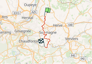

Lengte
22 km

Max. hoogte
274 m

Positief hoogteverschil
412 m
Km-Effort
28 km

Min. hoogte
99 m

Negatief hoogteverschil
525 m
Boucle
Neen
Datum van aanmaak :
2024-05-12 09:53:41.529
Laatste wijziging :
2024-05-12 14:35:51.128
4h22
Moeilijkheid : Gemakkelijk

Gratisgps-wandelapplicatie
 SityTrail
IGN / Geografische instituten
SityTrail Plus
De wereld gaat voor u open
Over ons
Tocht Stappen van 22 km beschikbaar op Wallonië, Luik, Blegny. Deze tocht wordt voorgesteld door Ko-Rando.
Foto's


Plaatsbepaling
Land:
Belgium
Regio :
Wallonië
Departement/Provincie :
Luik
Gemeente :
Blegny
Locatie:
Unknown
Vertrek:(Dec)
Vertrek:(UTM)
692263 ; 5616711 (31U) N.
Opmerkingen