


2024-05-13_14h29m45_GPX-FournatChatelard-PortesenValdaine

thonyc
Gebruiker GUIDE
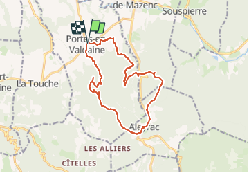

Lengte
15,3 km

Max. hoogte
474 m

Positief hoogteverschil
463 m
Km-Effort
21 km

Min. hoogte
224 m

Negatief hoogteverschil
462 m
Boucle
Ja
Datum van aanmaak :
2024-05-13 12:29:45.885
Laatste wijziging :
2024-09-30 15:07:09.099
4h52
Moeilijkheid : Zeer moeilijk

Gratisgps-wandelapplicatie
 SityTrail
IGN / Geografische instituten
SityTrail Plus
De wereld gaat voor u open
Over ons
Tocht Stappen van 15,3 km beschikbaar op Auvergne-Rhône-Alpes, Drôme, Portes-en-Valdaine. Deze tocht wordt voorgesteld door thonyc.
Plaatsbepaling
Land:
France
Regio :
Auvergne-Rhône-Alpes
Departement/Provincie :
Drôme
Gemeente :
Portes-en-Valdaine
Locatie:
Unknown
Vertrek:(Dec)
Vertrek:(UTM)
651893 ; 4932463 (31T) N.
Opmerkingen