


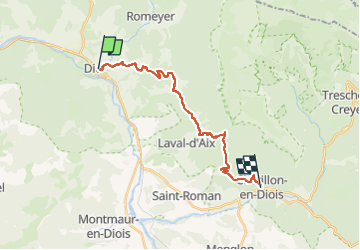
GR95 Die - Chatillon_Q3pE0

thonyc
Gebruiker GUIDE

Lengte
19 km

Max. hoogte
1162 m

Positief hoogteverschil
1288 m
Km-Effort
36 km

Min. hoogte
411 m

Negatief hoogteverschil
1112 m
Boucle
Neen
Datum van aanmaak :
2024-05-14 07:05:26.262
Laatste wijziging :
2024-05-14 07:05:26.262

Gratisgps-wandelapplicatie
 SityTrail
IGN / Geografische instituten
SityTrail Plus
De wereld gaat voor u open
Over ons
Tocht van 19 km beschikbaar op Auvergne-Rhône-Alpes, Drôme, Die. Deze tocht wordt voorgesteld door thonyc.
Plaatsbepaling
Land:
France
Regio :
Auvergne-Rhône-Alpes
Departement/Provincie :
Drôme
Gemeente :
Die
Locatie:
Unknown
Vertrek:(Dec)
Vertrek:(UTM)
687871 ; 4958281 (31T) N.
Opmerkingen