


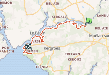
GR 34 Möelan s/mer - Kermeur (Kerfany)

nolsim
Gebruiker

Lengte
12,7 km

Max. hoogte
40 m

Positief hoogteverschil
202 m
Km-Effort
15,3 km

Min. hoogte
0 m

Negatief hoogteverschil
175 m
Boucle
Neen
Datum van aanmaak :
2024-05-16 07:33:48.656
Laatste wijziging :
2024-05-16 13:31:54.707
5h57
Moeilijkheid : Gemakkelijk

Gratisgps-wandelapplicatie
 SityTrail
IGN / Geografische instituten
SityTrail Plus
De wereld gaat voor u open
Over ons
Tocht Stappen van 12,7 km beschikbaar op Bretagne, Finistère, Moëlan-sur-Mer. Deze tocht wordt voorgesteld door nolsim.
Foto's
 - Photo 1")
 - Photo 2")
 - Photo 3")
 - Photo 4")
 - Photo 5")
 - Photo 6")
 - Photo 7")
 - Photo 8")
 - Photo 9")
 - Photo 10")
 - Photo 11")
 - Photo 12")
 - Photo 13")
 - Photo 14")
 - Photo 15")
Plaatsbepaling
Land:
France
Regio :
Bretagne
Departement/Provincie :
Finistère
Gemeente :
Moëlan-sur-Mer
Locatie:
Unknown
Vertrek:(Dec)
Vertrek:(UTM)
451193 ; 5296455 (30T) N.
Opmerkingen