


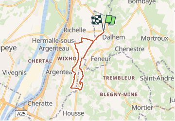
Dalhem-Richelle-La Bouhaye-Dalhem

chantalandre
Gebruiker

Lengte
9,3 km

Max. hoogte
157 m

Positief hoogteverschil
93 m
Km-Effort
10,5 km

Min. hoogte
112 m

Negatief hoogteverschil
93 m
Boucle
Ja
Datum van aanmaak :
2024-05-27 08:03:56.0
Laatste wijziging :
2025-08-06 18:57:14.945
2h23
Moeilijkheid : Medium

Gratisgps-wandelapplicatie
 SityTrail
IGN / Geografische instituten
SityTrail Plus
De wereld gaat voor u open
Over ons
Tocht Stappen van 9,3 km beschikbaar op Wallonië, Luik, Dalhem. Deze tocht wordt voorgesteld door chantalandre.
Plaatsbepaling
Land:
Belgium
Regio :
Wallonië
Departement/Provincie :
Luik
Gemeente :
Dalhem
Locatie:
Unknown
Vertrek:(Dec)
Vertrek:(UTM)
691730 ; 5621843 (31U) N.
Opmerkingen