


camping Aurvault

pierrol
Gebruiker
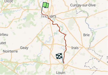

Lengte
28 km

Max. hoogte
112 m

Positief hoogteverschil
326 m
Km-Effort
32 km

Min. hoogte
45 m

Negatief hoogteverschil
278 m
Boucle
Neen
Datum van aanmaak :
2024-06-01 12:37:40.113
Laatste wijziging :
2024-06-01 12:37:43.225
1h55
Moeilijkheid : Moeilijk

Gratisgps-wandelapplicatie
 SityTrail
IGN / Geografische instituten
SityTrail Plus
De wereld gaat voor u open
Over ons
Tocht Fietstoerisme van 28 km beschikbaar op Nieuw-Aquitanië, Deux-Sèvres, Thouars. Deze tocht wordt voorgesteld door pierrol.
Plaatsbepaling
Land:
France
Regio :
Nieuw-Aquitanië
Departement/Provincie :
Deux-Sèvres
Gemeente :
Thouars
Locatie:
Unknown
Vertrek:(Dec)
Vertrek:(UTM)
709278 ; 5208051 (30T) N.
Opmerkingen