


2024 06 12 Chenonceau

chlafaille
Gebruiker
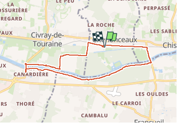

Lengte
8,5 km

Max. hoogte
74 m

Positief hoogteverschil
75 m
Km-Effort
9,5 km

Min. hoogte
51 m

Negatief hoogteverschil
76 m
Boucle
Ja
Datum van aanmaak :
2024-06-09 07:38:25.926
Laatste wijziging :
2024-06-09 09:36:52.205
1h58
Moeilijkheid : Gemakkelijk

Gratisgps-wandelapplicatie
 SityTrail
IGN / Geografische instituten
SityTrail Plus
De wereld gaat voor u open
Over ons
Tocht Stappen van 8,5 km beschikbaar op Centre-Val de Loire, Indre-et-Loire, Chenonceaux. Deze tocht wordt voorgesteld door chlafaille.
Plaatsbepaling
Land:
France
Regio :
Centre-Val de Loire
Departement/Provincie :
Indre-et-Loire
Gemeente :
Chenonceaux
Locatie:
Unknown
Vertrek:(Dec)
Vertrek:(UTM)
353952 ; 5243667 (31T) N.
Opmerkingen