


Haliru - Ban de Laviot

albert318
Gebruiker
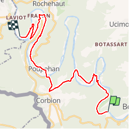

Lengte
15 km

Max. hoogte
362 m

Positief hoogteverschil
469 m
Km-Effort
21 km

Min. hoogte
193 m

Negatief hoogteverschil
487 m
Boucle
Neen
Datum van aanmaak :
2015-04-16 00:00:00.0
Laatste wijziging :
2015-04-16 00:00:00.0
4h30
Moeilijkheid : Gemakkelijk

Gratisgps-wandelapplicatie
 SityTrail
IGN / Geografische instituten
SityTrail Plus
De wereld gaat voor u open
Over ons
Tocht Stappen van 15 km beschikbaar op Wallonië, Luxemburg, Bouillon. Deze tocht wordt voorgesteld door albert318.
Plaatsbepaling
Land:
Belgium
Regio :
Wallonië
Departement/Provincie :
Luxemburg
Gemeente :
Bouillon
Locatie:
Corbion
Vertrek:(Dec)
Vertrek:(UTM)
647369 ; 5517568 (31U) N.
Opmerkingen