


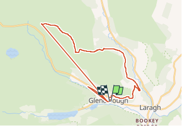
The Brockaghs and St Kevins Road

jaf299
Gebruiker

Lengte
16,7 km

Max. hoogte
552 m

Positief hoogteverschil
646 m
Km-Effort
25 km

Min. hoogte
133 m

Negatief hoogteverschil
644 m
Boucle
Ja
Datum van aanmaak :
2014-12-10 00:00:00.0
Laatste wijziging :
2014-12-10 00:00:00.0
--
Moeilijkheid : Onbekend

Gratisgps-wandelapplicatie
 SityTrail
IGN / Geografische instituten
SityTrail Plus
De wereld gaat voor u open
Over ons
Tocht Stappen van 16,7 km beschikbaar op Onbekend, County Wicklow, The Municipal District of Wicklow. Deze tocht wordt voorgesteld door jaf299.
Plaatsbepaling
Land:
Ireland
Regio :
Onbekend
Departement/Provincie :
County Wicklow
Gemeente :
The Municipal District of Wicklow
Locatie:
Brockagh
Vertrek:(Dec)
Vertrek:(UTM)
679484 ; 5876834 (29U) N.
Opmerkingen