


Circuit 8 chapelles 1

NUITEVEN
Gebruiker

Lengte
18 km

Max. hoogte
113 m

Positief hoogteverschil
319 m
Km-Effort
22 km

Min. hoogte
2 m

Negatief hoogteverschil
266 m
Boucle
Neen
Datum van aanmaak :
2017-12-03 00:00:00.0
Laatste wijziging :
2017-12-03 00:00:00.0
4h48
Moeilijkheid : Gemakkelijk

Gratisgps-wandelapplicatie
 SityTrail
IGN / Geografische instituten
SityTrail Plus
De wereld gaat voor u open
Over ons
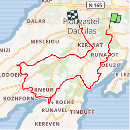
Tocht Stappen van 18 km beschikbaar op Bretagne, Finistère, Plougastel-Daoulas. Deze tocht wordt voorgesteld door NUITEVEN.
Plaatsbepaling
Land:
France
Regio :
Bretagne
Departement/Provincie :
Finistère
Gemeente :
Plougastel-Daoulas
Locatie:
Unknown
Vertrek:(Dec)
Vertrek:(UTM)
399906 ; 5358580 (30U) N.
Opmerkingen