Tocht Elektrische fiets Beaune - La ”Voie des Vignes” et la ”Voie des Étangs” - Photo

La ”Voie des Vignes” et la ”Voie des Étangs”

 micheldutilleul
micheldutilleul

Gebruiker

© OpenStreetMap contributors
Lengte
Lengte
49 km
Max. hoogte
Max. hoogte
294 m
Positief hoogteverschil
384 m
Km-Effort
Km-Effort  
54 km
Min. hoogte
Min. hoogte
192 m
Negatief hoogteverschil
384 m
Boucle
Boucle
Ja
Datum van aanmaak :
2024-07-09 08:12:35.281
Laatste wijziging :
2024-07-09 16:17:40.467

(0 Bericht)

Elektrische fiets
Elektrische fiets
4h54
Moeilijkheid : Gemakkelijk

Scan deze QR-code om de tocht te openen in de SityTrail-applicatie

Gratisgps-wandelapplicatie

Logo SityTrail SityTrail

IGN / Geografische instituten

SityTrail uit de App Store downloaden SityTrail uit Google Play downloaden

Logo SityTrail SityTrail Plus

De wereld gaat voor u open

SityTrail uit de App Store downloaden SityTrail uit Google Play downloaden SityTrail op Huawei AppGallery downloaden

Over ons

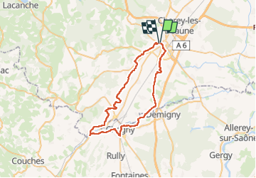
Tocht Elektrische fiets van 49 km beschikbaar op Bourgondië-Franche-Comté, Côte-d'Or, Beaune. Deze tocht wordt voorgesteld door micheldutilleul.

Beschrijving

De Beaune à Beaune : Suivre la "Voie des Vignes" de Beaune à Santenay; de Santenay à Chagny longer le Canal du Centre; de Chagny vers Beaune, suivre la "Voie des Etangs”

Hoogteprofiel

Plaatsbepaling

Land:
France
Regio :
Bourgondië-Franche-Comté
Departement/Provincie :
Côte-d'Or
Gemeente :
Beaune
Locatie:
Unknown
Vertrek:(UTM)
638988 ; 5209675 (31T) N.


Sluiten
Mijn abonnementen