


Hubert

kisic
Gebruiker
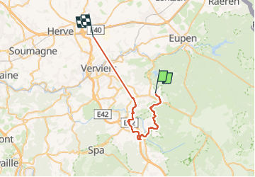

Lengte
32 km

Max. hoogte
467 m

Positief hoogteverschil
830 m
Km-Effort
43 km

Min. hoogte
171 m

Negatief hoogteverschil
965 m
Boucle
Neen
Datum van aanmaak :
2024-07-11 07:22:52.0
Laatste wijziging :
2024-07-11 15:58:37.159
6h17
Moeilijkheid : Zeer moeilijk

Gratisgps-wandelapplicatie
 SityTrail
IGN / Geografische instituten
SityTrail Plus
De wereld gaat voor u open
Over ons
Tocht Stappen van 32 km beschikbaar op Wallonië, Luik, Jalhay. Deze tocht wordt voorgesteld door kisic.
Beschrijving
Marche
Plaatsbepaling
Land:
Belgium
Regio :
Wallonië
Departement/Provincie :
Luik
Gemeente :
Jalhay
Locatie:
Unknown
Vertrek:(Dec)
Vertrek:(UTM)
710919 ; 5605382 (31U) N.
Opmerkingen