


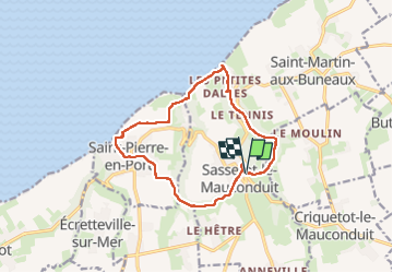
sasetot le Mauconduit-Château de Sissi

MichelRando7656
Gebruiker

Lengte
12,5 km

Max. hoogte
96 m

Positief hoogteverschil
227 m
Km-Effort
15,6 km

Min. hoogte
7 m

Negatief hoogteverschil
226 m
Boucle
Ja
Datum van aanmaak :
2024-07-21 07:57:36.378
Laatste wijziging :
2024-07-22 01:07:32.336
4h45
Moeilijkheid : Moeilijk

Gratisgps-wandelapplicatie
 SityTrail
IGN / Geografische instituten
SityTrail Plus
De wereld gaat voor u open
Over ons
Tocht Stappen van 12,5 km beschikbaar op Normandië, Seine-Maritime, Sassetot-le-Mauconduit. Deze tocht wordt voorgesteld door MichelRando7656.
Beschrijving
Beau circuit
Foto's


Plaatsbepaling
Land:
France
Regio :
Normandië
Departement/Provincie :
Seine-Maritime
Gemeente :
Sassetot-le-Mauconduit
Locatie:
Unknown
Vertrek:(Dec)
Vertrek:(UTM)
322400 ; 5519694 (31U) N.
Opmerkingen