


descente depuis les Orres en vtt

guariso
Gebruiker

Lengte
11,5 km

Max. hoogte
1475 m

Positief hoogteverschil
96 m
Km-Effort
15 km

Min. hoogte
782 m

Negatief hoogteverschil
782 m
Boucle
Neen
Datum van aanmaak :
2024-07-23 12:36:24.066
Laatste wijziging :
2024-07-23 15:22:05.519
2h44
Moeilijkheid : Moeilijk

Gratisgps-wandelapplicatie
 SityTrail
IGN / Geografische instituten
SityTrail Plus
De wereld gaat voor u open
Over ons
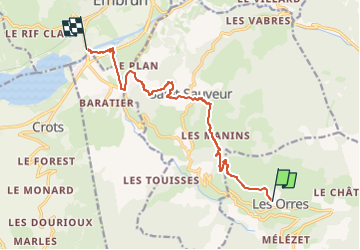
Tocht Mountainbike van 11,5 km beschikbaar op Provence-Alpes-Côte d'Azur, Hautes-Alpes, Les Orres. Deze tocht wordt voorgesteld door guariso.
Beschrijving
Attention pas une descente à la portée des débutants, ce n'est pas une boucle.
Plaatsbepaling
Land:
France
Regio :
Provence-Alpes-Côte d'Azur
Departement/Provincie :
Hautes-Alpes
Gemeente :
Les Orres
Locatie:
Unknown
Vertrek:(Dec)
Vertrek:(UTM)
305125 ; 4931969 (32T) N.
Opmerkingen