


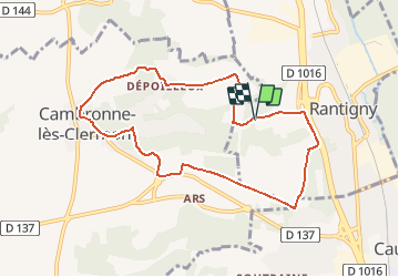
Rantigny_La Vallée de Vaux_8,1 km

Pousscailleux
Gebruiker


2h02
Moeilijkheid : Gemakkelijk

Gratisgps-wandelapplicatie
 SityTrail
IGN / Geografische instituten
SityTrail Plus
De wereld gaat voor u open
Over ons
Tocht Stappen van 8 km beschikbaar op Hauts-de-France, Oise, Rantigny. Deze tocht wordt voorgesteld door Pousscailleux.
Beschrijving
Départ du nouveau cimetière de Rantigny. Coordonnées GPS : N49°19'48.14"/E002°25'35.37". Totalement balisé en jaune, cet itinéraire reprend une partie du circuit "La montagne de Rantigny" www.oise-randonnee.com.
Plaatsbepaling
Opmerkingen