


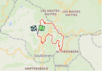
11/08/24 - Soultzeren

delm
Gebruiker

Lengte
13,5 km

Max. hoogte
952 m

Positief hoogteverschil
495 m
Km-Effort
20 km

Min. hoogte
597 m

Negatief hoogteverschil
501 m
Boucle
Ja
Datum van aanmaak :
2024-08-11 09:28:18.0
Laatste wijziging :
2024-08-11 15:20:46.202

Gratisgps-wandelapplicatie
 SityTrail
IGN / Geografische instituten
SityTrail Plus
De wereld gaat voor u open
Over ons
Tocht van 13,5 km beschikbaar op Grand Est, Haut-Rhin, Soultzeren. Deze tocht wordt voorgesteld door delm.
Beschrijving
Très belle randonnée
Plaatsbepaling
Land:
France
Regio :
Grand Est
Departement/Provincie :
Haut-Rhin
Gemeente :
Soultzeren
Locatie:
Unknown
Vertrek:(Dec)
Vertrek:(UTM)
358260 ; 5326920 (32U) N.
Opmerkingen