


15/08/24 - Diffenthal

delm
Gebruiker
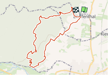

Lengte
10,5 km

Max. hoogte
468 m

Positief hoogteverschil
377 m
Km-Effort
15,5 km

Min. hoogte
201 m

Negatief hoogteverschil
382 m
Boucle
Ja
Datum van aanmaak :
2024-08-15 09:29:02.0
Laatste wijziging :
2024-08-15 14:32:55.806

Gratisgps-wandelapplicatie
 SityTrail
IGN / Geografische instituten
SityTrail Plus
De wereld gaat voor u open
Over ons
Tocht van 10,5 km beschikbaar op Grand Est, Bas-Rhin, Dieffenthal. Deze tocht wordt voorgesteld door delm.
Plaatsbepaling
Land:
France
Regio :
Grand Est
Departement/Provincie :
Bas-Rhin
Gemeente :
Dieffenthal
Locatie:
Unknown
Vertrek:(Dec)
Vertrek:(UTM)
382594 ; 5351876 (32U) N.
Opmerkingen