


J5 Kassel

werth
Gebruiker

Lengte
62 km

Max. hoogte
347 m

Positief hoogteverschil
462 m
Km-Effort
68 km

Min. hoogte
136 m

Negatief hoogteverschil
669 m
Boucle
Neen
Datum van aanmaak :
2024-08-22 07:33:04.531
Laatste wijziging :
2024-08-22 14:28:47.394
6h54
Moeilijkheid : Medium

Gratisgps-wandelapplicatie
 SityTrail
IGN / Geografische instituten
SityTrail Plus
De wereld gaat voor u open
Over ons
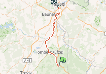
Tocht Fietstoerisme van 62 km beschikbaar op Hessen, Schwalm-Eder-Kreis, Knüllwald. Deze tocht wordt voorgesteld door werth.
Plaatsbepaling
Land:
Germany
Regio :
Hessen
Departement/Provincie :
Schwalm-Eder-Kreis
Gemeente :
Knüllwald
Locatie:
Wallenstein
Vertrek:(Dec)
Vertrek:(UTM)
534795 ; 5644285 (32U) N.
Opmerkingen