


trace

ochelen
Gebruiker
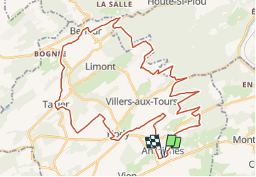

Lengte
25 km

Max. hoogte
298 m

Positief hoogteverschil
530 m
Km-Effort
32 km

Min. hoogte
148 m

Negatief hoogteverschil
530 m
Boucle
Ja
Datum van aanmaak :
2015-05-07 00:00:00.0
Laatste wijziging :
2015-05-07 00:00:00.0
--
Moeilijkheid : Onbekend

Gratisgps-wandelapplicatie
 SityTrail
IGN / Geografische instituten
SityTrail Plus
De wereld gaat voor u open
Over ons
Tocht Andere activiteiten van 25 km beschikbaar op Wallonië, Luik, Anthisnes. Deze tocht wordt voorgesteld door ochelen.
Plaatsbepaling
Land:
Belgium
Regio :
Wallonië
Departement/Provincie :
Luik
Gemeente :
Anthisnes
Locatie:
Anthisnes
Vertrek:(Dec)
Vertrek:(UTM)
678999 ; 5594992 (31U) N.
Opmerkingen