


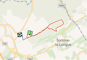
SorinneLL Bois uniquement, remontée long ruisselet topissime

thomarche
Gebruiker

Lengte
5,1 km

Max. hoogte
281 m

Positief hoogteverschil
81 m
Km-Effort
6,1 km

Min. hoogte
218 m

Negatief hoogteverschil
80 m
Boucle
Ja
Datum van aanmaak :
2024-09-08 08:39:07.0
Laatste wijziging :
2024-12-12 11:17:58.347
1h23
Moeilijkheid : Gemakkelijk

Gratisgps-wandelapplicatie
 SityTrail
IGN / Geografische instituten
SityTrail Plus
De wereld gaat voor u open
Over ons
Tocht Stappen van 5,1 km beschikbaar op Wallonië, Namen, Assesse. Deze tocht wordt voorgesteld door thomarche.
Beschrijving
Ptite boucle, sublimissime bain de forêt. Chemins praticables même sous pluie, gros rochers moussus avec mini ruisseau mini cascades, un régal.
Plaatsbepaling
Land:
Belgium
Regio :
Wallonië
Departement/Provincie :
Namen
Gemeente :
Assesse
Locatie:
Unknown
Vertrek:(Dec)
Vertrek:(UTM)
642403 ; 5584086 (31U) N.
Opmerkingen