


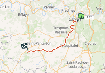
Compostelle Cahors Moncuq

Nono55
Gebruiker

Lengte
39 km

Max. hoogte
305 m

Positief hoogteverschil
720 m
Km-Effort
48 km

Min. hoogte
112 m

Negatief hoogteverschil
652 m
Boucle
Neen
Datum van aanmaak :
2024-09-09 05:56:21.0
Laatste wijziging :
2024-09-09 15:58:10.884
7h23
Moeilijkheid : Medium

Gratisgps-wandelapplicatie
 SityTrail
IGN / Geografische instituten
SityTrail Plus
De wereld gaat voor u open
Over ons
Tocht Stappen van 39 km beschikbaar op Occitanië, Lot, Cahors. Deze tocht wordt voorgesteld door Nono55.
Beschrijving
Journée sous la pluie Etape vallonné sur les Causses quelles montées difficiles
Plaatsbepaling
Land:
France
Regio :
Occitanië
Departement/Provincie :
Lot
Gemeente :
Cahors
Locatie:
Unknown
Vertrek:(Dec)
Vertrek:(UTM)
376416 ; 4921742 (31T) N.
Opmerkingen