


cucurln

phil21
Gebruiker
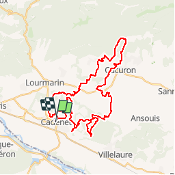

Lengte
43 km

Max. hoogte
554 m

Positief hoogteverschil
1087 m
Km-Effort
58 km

Min. hoogte
185 m

Negatief hoogteverschil
1076 m
Boucle
Neen
Datum van aanmaak :
2015-05-09 00:00:00.0
Laatste wijziging :
2015-05-09 00:00:00.0
5h56
Moeilijkheid : Gemakkelijk

Gratisgps-wandelapplicatie
 SityTrail
IGN / Geografische instituten
SityTrail Plus
De wereld gaat voor u open
Over ons
Tocht Mountainbike van 43 km beschikbaar op Provence-Alpes-Côte d'Azur, Vaucluse, Cadenet. Deze tocht wordt voorgesteld door phil21.
Plaatsbepaling
Land:
France
Regio :
Provence-Alpes-Côte d'Azur
Departement/Provincie :
Vaucluse
Gemeente :
Cadenet
Locatie:
Unknown
Vertrek:(Dec)
Vertrek:(UTM)
691155 ; 4845127 (31T) N.
Opmerkingen