


Blanzey

any1950
Gebruiker
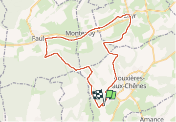

Lengte
18,9 km

Max. hoogte
413 m

Positief hoogteverschil
395 m
Km-Effort
24 km

Min. hoogte
233 m

Negatief hoogteverschil
395 m
Boucle
Ja
Datum van aanmaak :
2024-09-12 06:34:30.835
Laatste wijziging :
2024-09-12 12:17:23.828
4h41
Moeilijkheid : Heel gemakkelijk

Gratisgps-wandelapplicatie
 SityTrail
IGN / Geografische instituten
SityTrail Plus
De wereld gaat voor u open
Over ons
Tocht Stappen van 18,9 km beschikbaar op Grand Est, Meurthe-et-Moselle, Bouxières-aux-Chênes. Deze tocht wordt voorgesteld door any1950.
Plaatsbepaling
Land:
France
Regio :
Grand Est
Departement/Provincie :
Meurthe-et-Moselle
Gemeente :
Bouxières-aux-Chênes
Locatie:
Unknown
Vertrek:(Dec)
Vertrek:(UTM)
297594 ; 5404514 (32U) N.
Opmerkingen