


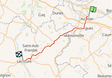
Compostelle Espalais a Lectoure

Nono55
Gebruiker

Lengte
45 km

Max. hoogte
214 m

Positief hoogteverschil
824 m
Km-Effort
55 km

Min. hoogte
56 m

Negatief hoogteverschil
702 m
Boucle
Neen
Datum van aanmaak :
2024-09-12 05:55:13.0
Laatste wijziging :
2024-09-12 19:36:49.866
8h20
Moeilijkheid : Medium

Gratisgps-wandelapplicatie
 SityTrail
IGN / Geografische instituten
SityTrail Plus
De wereld gaat voor u open
Over ons
Tocht Stappen van 45 km beschikbaar op Occitanië, Tarn-et-Garonne, Espalais. Deze tocht wordt voorgesteld door Nono55.
Beschrijving
Chemin vallonné au départ et la fin beaucoup de route arrivé à Lectoure très jolie village
Plaatsbepaling
Land:
France
Regio :
Occitanië
Departement/Provincie :
Tarn-et-Garonne
Gemeente :
Espalais
Locatie:
Unknown
Vertrek:(Dec)
Vertrek:(UTM)
332386 ; 4882588 (31T) N.
Opmerkingen