


Compostelle Lectoure a Castelnau sur l Auviovion

Nono55
Gebruiker
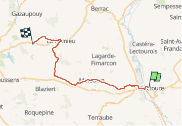

Lengte
27 km

Max. hoogte
220 m

Positief hoogteverschil
443 m
Km-Effort
33 km

Min. hoogte
77 m

Negatief hoogteverschil
467 m
Boucle
Neen
Datum van aanmaak :
2024-09-13 05:40:15.0
Laatste wijziging :
2024-09-13 13:36:57.262
4h58
Moeilijkheid : Medium

Gratisgps-wandelapplicatie
 SityTrail
IGN / Geografische instituten
SityTrail Plus
De wereld gaat voor u open
Over ons
Tocht Stappen van 27 km beschikbaar op Occitanië, Gers, Lectoure. Deze tocht wordt voorgesteld door Nono55.
Beschrijving
Petite étape 23 km vallonné quelques montée sèches .Village de Lectoure et Romieu magnifique arrêt au gîte L encre tenue pas des jeunes sympa
Plaatsbepaling
Land:
France
Regio :
Occitanië
Departement/Provincie :
Gers
Gemeente :
Lectoure
Locatie:
Unknown
Vertrek:(Dec)
Vertrek:(UTM)
308771 ; 4867445 (31T) N.
Opmerkingen