


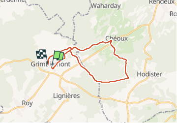
Grimbièmont DEPS

thomarche
Gebruiker

Lengte
11,8 km

Max. hoogte
431 m

Positief hoogteverschil
362 m
Km-Effort
16,5 km

Min. hoogte
260 m

Negatief hoogteverschil
337 m
Boucle
Ja
Datum van aanmaak :
2024-09-15 11:39:56.0
Laatste wijziging :
2024-09-15 14:35:37.84
2h49
Moeilijkheid : Onbekend

Gratisgps-wandelapplicatie
 SityTrail
IGN / Geografische instituten
SityTrail Plus
De wereld gaat voor u open
Over ons
Tocht Stappen van 11,8 km beschikbaar op Wallonië, Luxemburg, Marche-en-Famenne. Deze tocht wordt voorgesteld door thomarche.
Beschrijving
Magnifique boucle avec quasi aucun macadam et de très beaux sentiers bois. Et belles vues.
Plaatsbepaling
Land:
Belgium
Regio :
Wallonië
Departement/Provincie :
Luxemburg
Gemeente :
Marche-en-Famenne
Locatie:
Unknown
Vertrek:(Dec)
Vertrek:(UTM)
673198 ; 5564137 (31U) N.
Opmerkingen