


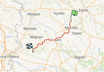
Compostelle Mancier a Gîte Dubarry

Nono55
Gebruiker

Lengte
34 km

Max. hoogte
167 m

Positief hoogteverschil
462 m
Km-Effort
41 km

Min. hoogte
92 m

Negatief hoogteverschil
476 m
Boucle
Neen
Datum van aanmaak :
2024-09-16 05:42:44.0
Laatste wijziging :
2024-09-16 14:20:11.143
6h33
Moeilijkheid : Gemakkelijk

Gratisgps-wandelapplicatie
 SityTrail
IGN / Geografische instituten
SityTrail Plus
De wereld gaat voor u open
Over ons
Tocht Stappen van 34 km beschikbaar op Occitanië, Gers, Manciet. Deze tocht wordt voorgesteld door Nono55.
Beschrijving
Départ un peu dangereux sur la route puis chemin en sous bois sympa Arrive au gîte Dubarry chemin pourri

Plaatsbepaling
Land:
France
Regio :
Occitanië
Departement/Provincie :
Gers
Gemeente :
Manciet
Locatie:
Unknown
Vertrek:(Dec)
Vertrek:(UTM)
262046 ; 4857184 (31T) N.
Opmerkingen