


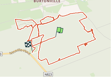
Marche d’orientation Justine

alfreson
Gebruiker

Lengte
10,5 km

Max. hoogte
582 m

Positief hoogteverschil
213 m
Km-Effort
13,4 km

Min. hoogte
491 m

Negatief hoogteverschil
243 m
Boucle
Neen
Datum van aanmaak :
2024-09-15 13:28:45.0
Laatste wijziging :
2024-09-21 20:02:41.23
4h02
Moeilijkheid : Moeilijk

Gratisgps-wandelapplicatie
 SityTrail
IGN / Geografische instituten
SityTrail Plus
De wereld gaat voor u open
Over ons
Tocht Stappen van 10,5 km beschikbaar op Wallonië, Luxemburg, Vielsalm. Deze tocht wordt voorgesteld door alfreson.
Beschrijving
Et il manque le début
Foto's

Plaatsbepaling
Land:
Belgium
Regio :
Wallonië
Departement/Provincie :
Luxemburg
Gemeente :
Vielsalm
Locatie:
Unknown
Vertrek:(Dec)
Vertrek:(UTM)
711459 ; 5573720 (31U) N.
Opmerkingen