


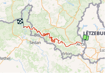
GR 16 - Parcours principal - 2024-06-15

ramagufa
Gebruiker

Lengte
209 km

Max. hoogte
451 m

Positief hoogteverschil
5291 m
Km-Effort
281 km

Min. hoogte
137 m

Negatief hoogteverschil
5549 m
Boucle
Neen
Datum van aanmaak :
2024-09-28 18:36:58.057
Laatste wijziging :
2024-09-28 18:38:05.514
63h50
Moeilijkheid : Moeilijk

Gratisgps-wandelapplicatie
 SityTrail
IGN / Geografische instituten
SityTrail Plus
De wereld gaat voor u open
Over ons
Tocht Te voet van 209 km beschikbaar op Wallonië, Luxemburg, Aarlen. Deze tocht wordt voorgesteld door ramagufa.
Beschrijving
Le nouveau tracé du GR 16
Plaatsbepaling
Land:
Belgium
Regio :
Wallonië
Departement/Provincie :
Luxemburg
Gemeente :
Aarlen
Locatie:
Aarlen
Vertrek:(Dec)
Vertrek:(UTM)
703438 ; 5507051 (31U) N.
Opmerkingen