


allondrelle 10.10.2024

jcb48
Gebruiker

Lengte
7,2 km

Max. hoogte
370 m

Positief hoogteverschil
206 m
Km-Effort
10 km

Min. hoogte
278 m

Negatief hoogteverschil
205 m
Boucle
Ja
Datum van aanmaak :
2024-10-06 08:07:06.469
Laatste wijziging :
2024-10-06 08:07:57.197
2h16
Moeilijkheid : Gemakkelijk

Gratisgps-wandelapplicatie
 SityTrail
IGN / Geografische instituten
SityTrail Plus
De wereld gaat voor u open
Over ons
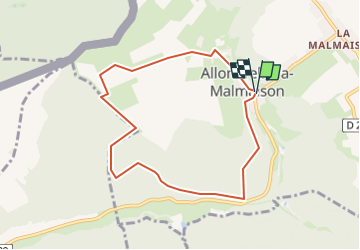
Tocht Te voet van 7,2 km beschikbaar op Grand Est, Meurthe-et-Moselle, Allondrelle-la-Malmaison. Deze tocht wordt voorgesteld door jcb48.
Beschrijving
marche
Plaatsbepaling
Land:
France
Regio :
Grand Est
Departement/Provincie :
Meurthe-et-Moselle
Gemeente :
Allondrelle-la-Malmaison
Locatie:
Unknown
Vertrek:(Dec)
Vertrek:(UTM)
685702 ; 5487243 (31U) N.
Opmerkingen