


Test UTDF

cps46
Gebruiker

Lengte
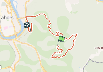
11 km

Max. hoogte
281 m

Positief hoogteverschil
555 m
Km-Effort
18,4 km

Min. hoogte
126 m

Negatief hoogteverschil
554 m
Boucle
Neen
Datum van aanmaak :
2024-10-12 07:55:54.0
Laatste wijziging :
2024-10-12 12:08:57.604

Gratisgps-wandelapplicatie
 SityTrail
IGN / Geografische instituten
SityTrail Plus
De wereld gaat voor u open
Over ons
Tocht van 11 km beschikbaar op Occitanië, Lot, Cahors. Deze tocht wordt voorgesteld door cps46.

Plaatsbepaling
Land:
France
Regio :
Occitanië
Departement/Provincie :
Lot
Gemeente :
Cahors
Locatie:
Unknown
Vertrek:(Dec)
Vertrek:(UTM)
378053 ; 4921612 (31T) N.
Opmerkingen