


sortie Dabo 13/10

Titinechris
Gebruiker
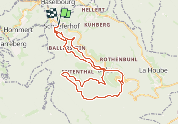

Lengte
20 km

Max. hoogte
621 m

Positief hoogteverschil
633 m
Km-Effort
29 km

Min. hoogte
307 m

Negatief hoogteverschil
634 m
Boucle
Ja
Datum van aanmaak :
2024-10-12 12:24:21.735
Laatste wijziging :
2024-10-12 12:24:29.708
3h30
Moeilijkheid : Heel gemakkelijk

Gratisgps-wandelapplicatie
 SityTrail
IGN / Geografische instituten
SityTrail Plus
De wereld gaat voor u open
Over ons
Tocht Trail van 20 km beschikbaar op Grand Est, Moselle, Dabo. Deze tocht wordt voorgesteld door Titinechris.
Plaatsbepaling
Land:
France
Regio :
Grand Est
Departement/Provincie :
Moselle
Gemeente :
Dabo
Locatie:
Unknown
Vertrek:(Dec)
Vertrek:(UTM)
367829 ; 5392811 (32U) N.
Opmerkingen