


Sob strenquels

Glurps
Gebruiker

Lengte
2,5 km

Max. hoogte
241 m

Positief hoogteverschil
117 m
Km-Effort
3,7 km

Min. hoogte
123 m

Negatief hoogteverschil
5 m
Boucle
Neen
Datum van aanmaak :
2024-10-14 13:48:22.0
Laatste wijziging :
2024-10-15 06:54:12.612

Gratisgps-wandelapplicatie
 SityTrail
IGN / Geografische instituten
SityTrail Plus
De wereld gaat voor u open
Over ons
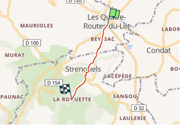
Tocht van 2,5 km beschikbaar op Occitanië, Lot, Le Vignon-en-Quercy. Deze tocht wordt voorgesteld door Glurps.
Plaatsbepaling
Land:
France
Regio :
Occitanië
Departement/Provincie :
Lot
Gemeente :
Le Vignon-en-Quercy
Locatie:
Unknown
Vertrek:(Dec)
Vertrek:(UTM)
393279 ; 4983392 (31T) N.
Opmerkingen