


St2024 dim

PhilippeC54
Gebruiker
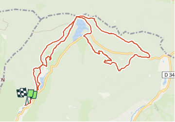

Lengte
12,8 km

Max. hoogte
1067 m

Positief hoogteverschil
377 m
Km-Effort
17,8 km

Min. hoogte
836 m

Negatief hoogteverschil
370 m
Boucle
Ja
Datum van aanmaak :
2024-10-27 13:00:58.247
Laatste wijziging :
2024-10-28 06:01:03.35
1h31
Moeilijkheid : Gemakkelijk

Gratisgps-wandelapplicatie
 SityTrail
IGN / Geografische instituten
SityTrail Plus
De wereld gaat voor u open
Over ons
Tocht Mountainbike van 12,8 km beschikbaar op Grand Est, Vogezen, La Bresse. Deze tocht wordt voorgesteld door PhilippeC54.
Plaatsbepaling
Land:
France
Regio :
Grand Est
Departement/Provincie :
Vogezen
Gemeente :
La Bresse
Locatie:
Unknown
Vertrek:(Dec)
Vertrek:(UTM)
345307 ; 5322402 (32U) N.
Opmerkingen