


Crémaillère 2 Isabelle Conflans

sebastienu
Gebruiker

Lengte
9,9 km

Max. hoogte
177 m

Positief hoogteverschil
168 m
Km-Effort
12,2 km

Min. hoogte
115 m

Negatief hoogteverschil
176 m
Boucle
Ja
Datum van aanmaak :
2024-10-20 09:34:04.444
Laatste wijziging :
2024-11-03 14:36:25.7
3h31
Moeilijkheid : Moeilijk

Gratisgps-wandelapplicatie
 SityTrail
IGN / Geografische instituten
SityTrail Plus
De wereld gaat voor u open
Over ons
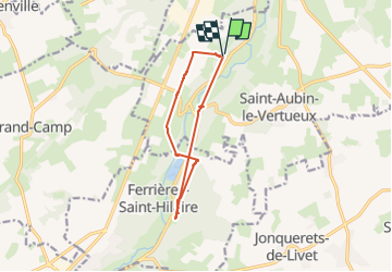
Tocht Stappen van 9,9 km beschikbaar op Normandië, Eure, Treis-Sants-en-Ouche. Deze tocht wordt voorgesteld door sebastienu.
Plaatsbepaling
Land:
France
Regio :
Normandië
Departement/Provincie :
Eure
Gemeente :
Treis-Sants-en-Ouche
Locatie:
Unknown
Vertrek:(Dec)
Vertrek:(UTM)
323865 ; 5437088 (31U) N.
Opmerkingen