


PP et autour

Titinechris
Gebruiker
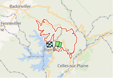

Lengte
19,3 km

Max. hoogte
564 m

Positief hoogteverschil
630 m
Km-Effort
28 km

Min. hoogte
323 m

Negatief hoogteverschil
628 m
Boucle
Ja
Datum van aanmaak :
2024-11-16 06:44:04.006
Laatste wijziging :
2024-11-16 06:45:28.332
3m
Moeilijkheid : Gemakkelijk

Gratisgps-wandelapplicatie
 SityTrail
IGN / Geografische instituten
SityTrail Plus
De wereld gaat voor u open
Over ons
Tocht Trail van 19,3 km beschikbaar op Grand Est, Meurthe-et-Moselle, Pierre-Percée. Deze tocht wordt voorgesteld door Titinechris.
Plaatsbepaling
Land:
France
Regio :
Grand Est
Departement/Provincie :
Meurthe-et-Moselle
Gemeente :
Pierre-Percée
Locatie:
Unknown
Vertrek:(Dec)
Vertrek:(UTM)
346983 ; 5370322 (32U) N.
Opmerkingen