


un dimanche matin avec les copains

Tollard
Gebruiker

Lengte
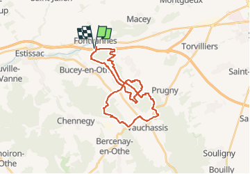
29 km

Max. hoogte
267 m

Positief hoogteverschil
518 m
Km-Effort
36 km

Min. hoogte
147 m

Negatief hoogteverschil
519 m
Boucle
Ja
Datum van aanmaak :
2024-11-17 08:03:57.519
Laatste wijziging :
2024-11-24 11:35:14.164
2h48
Moeilijkheid : Moeilijk

Gratisgps-wandelapplicatie
 SityTrail
IGN / Geografische instituten
SityTrail Plus
De wereld gaat voor u open
Over ons
Tocht Mountainbike van 29 km beschikbaar op Grand Est, Aube, Fontvannes. Deze tocht wordt voorgesteld door Tollard.
Plaatsbepaling
Land:
France
Regio :
Grand Est
Departement/Provincie :
Aube
Gemeente :
Fontvannes
Locatie:
Unknown
Vertrek:(Dec)
Vertrek:(UTM)
564725 ; 5347035 (31U) N.
Opmerkingen