


DURACELLE 2015

Tollard
Gebruiker

Lengte
53 km

Max. hoogte
310 m

Positief hoogteverschil
1019 m
Km-Effort
66 km

Min. hoogte
146 m

Negatief hoogteverschil
1020 m
Boucle
Ja
Datum van aanmaak :
2015-06-02 00:00:00.0
Laatste wijziging :
2015-06-02 00:00:00.0
4h13
Moeilijkheid : Moeilijk

Gratisgps-wandelapplicatie
 SityTrail
IGN / Geografische instituten
SityTrail Plus
De wereld gaat voor u open
Over ons
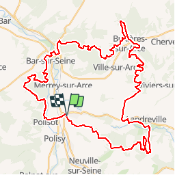
Tocht Mountainbike van 53 km beschikbaar op Grand Est, Aube, Celles-sur-Ource. Deze tocht wordt voorgesteld door Tollard.
Beschrijving
derrière BERGERE c'est indiscutablement le plus beau parcours du département de l'Aube.
5 étoiles
Plaatsbepaling
Land:
France
Regio :
Grand Est
Departement/Provincie :
Aube
Gemeente :
Celles-sur-Ource
Locatie:
Unknown
Vertrek:(Dec)
Vertrek:(UTM)
603801 ; 5325619 (31U) N.
Opmerkingen