


Fond des 4 vaux

PhilippeC54
Gebruiker

Lengte
29 km

Max. hoogte
374 m

Positief hoogteverschil
544 m
Km-Effort
36 km

Min. hoogte
178 m

Negatief hoogteverschil
544 m
Boucle
Ja
Datum van aanmaak :
2025-01-04 12:32:57.499
Laatste wijziging :
2025-01-04 14:51:34.148
2h18
Moeilijkheid : Medium

Gratisgps-wandelapplicatie
 SityTrail
IGN / Geografische instituten
SityTrail Plus
De wereld gaat voor u open
Over ons
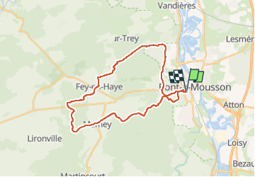
Tocht Mountainbike van 29 km beschikbaar op Grand Est, Meurthe-et-Moselle, Pont-à-Mousson. Deze tocht wordt voorgesteld door PhilippeC54.
Plaatsbepaling
Land:
France
Regio :
Grand Est
Departement/Provincie :
Meurthe-et-Moselle
Gemeente :
Pont-à-Mousson
Locatie:
Unknown
Vertrek:(Dec)
Vertrek:(UTM)
283581 ; 5420465 (32U) N.
Opmerkingen