


cascade de Battion

thomas1986
Gebruiker
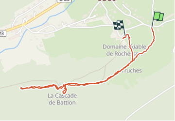

Lengte
2,4 km

Max. hoogte
672 m

Positief hoogteverschil
108 m
Km-Effort
3,9 km

Min. hoogte
588 m

Negatief hoogteverschil
121 m
Boucle
Ja
Datum van aanmaak :
2025-01-11 11:34:28.318
Laatste wijziging :
2025-01-11 12:49:38.065
55m
Moeilijkheid : Gemakkelijk

Gratisgps-wandelapplicatie
 SityTrail
IGN / Geografische instituten
SityTrail Plus
De wereld gaat voor u open
Over ons
Tocht Stappen van 2,4 km beschikbaar op Grand Est, Vogezen, Rochesson. Deze tocht wordt voorgesteld door thomas1986.
Foto's


Plaatsbepaling
Land:
France
Regio :
Grand Est
Departement/Provincie :
Vogezen
Gemeente :
Rochesson
Locatie:
Unknown
Vertrek:(Dec)
Vertrek:(UTM)
337686 ; 5321523 (32U) N.
Opmerkingen