


Le chapelier bis

coglais
Gebruiker

Lengte
12,5 km

Max. hoogte
194 m

Positief hoogteverschil
232 m
Km-Effort
15,6 km

Min. hoogte
118 m

Negatief hoogteverschil
233 m
Boucle
Ja
Datum van aanmaak :
2025-01-20 12:41:19.802
Laatste wijziging :
2025-01-20 15:36:00.987
2h35
Moeilijkheid : Heel gemakkelijk

Gratisgps-wandelapplicatie
 SityTrail
IGN / Geografische instituten
SityTrail Plus
De wereld gaat voor u open
Over ons
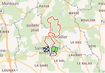
Tocht Noords wandelen van 12,5 km beschikbaar op Bretagne, Ille-et-Vilaine, Saint-Germain-en-Coglès. Deze tocht wordt voorgesteld door coglais.
Plaatsbepaling
Land:
France
Regio :
Bretagne
Departement/Provincie :
Ille-et-Vilaine
Gemeente :
Saint-Germain-en-Coglès
Locatie:
Unknown
Vertrek:(Dec)
Vertrek:(UTM)
628723 ; 5362320 (30U) N.
Opmerkingen