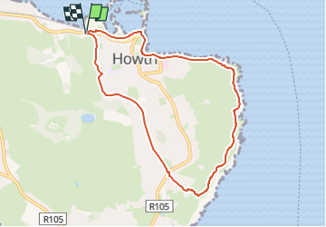
Tocht Te voet Onbekend - Howth Tramline Loop - Photo

Howth Tramline Loop

Tous les sentiers balisés d’Europe GUIDE+

© OpenStreetMap contributors
Lengte
Lengte
7 km
Max. hoogte
Max. hoogte
140 m
Positief hoogteverschil
159 m
Km-Effort
Km-Effort  
9,1 km
Min. hoogte
Min. hoogte
0 m
Negatief hoogteverschil
154 m
Boucle
Boucle
Ja
Markering
Markering
Datum van aanmaak :
2025-02-06 13:10:26.057
Laatste wijziging :
2025-02-06 13:10:26.057

(0 Bericht)

Te voet
Te voet
2h04
Moeilijkheid : Gemakkelijk

Scan deze QR-code om de tocht te openen in de SityTrail-applicatie

Gratisgps-wandelapplicatie

Logo SityTrail SityTrail

IGN / Geografische instituten

SityTrail uit de App Store downloaden SityTrail uit Google Play downloaden

Logo SityTrail SityTrail Plus

De wereld gaat voor u open

SityTrail uit de App Store downloaden SityTrail uit Google Play downloaden SityTrail op Huawei AppGallery downloaden

Over ons

Tocht Te voet van 7 km beschikbaar op Onbekend, Onbekend, Onbekend. Deze tocht wordt voorgesteld door SityTrail - itinéraires balisés pédestres.

Beschrijving

Symbool: Blue arrow on white background


Website: https://www.irishtrails.ie/Trail/Howth---Tramline-loop/108/

Hoogteprofiel

Foto's

Plaatsbepaling

Land:
Ireland
Regio :
Onbekend
Departement/Provincie :
Onbekend
Gemeente :
Onbekend
Locatie:
Ballymun C ED
Vertrek:(UTM)
694562 ; 5919506 (29U) N.


Sluiten
Mijn abonnementen