


Arton Gembloux Petit8

thomarche
Gebruiker
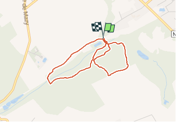

Lengte
3,6 km

Max. hoogte
168 m

Positief hoogteverschil
56 m
Km-Effort
4,3 km

Min. hoogte
130 m

Negatief hoogteverschil
57 m
Boucle
Ja
Datum van aanmaak :
2025-02-14 11:54:52.0
Laatste wijziging :
2025-02-14 12:41:43.829
46m
Moeilijkheid : Gemakkelijk

Gratisgps-wandelapplicatie
 SityTrail
IGN / Geografische instituten
SityTrail Plus
De wereld gaat voor u open
Over ons
Tocht Stappen van 3,6 km beschikbaar op Wallonië, Namen, Gembloers. Deze tocht wordt voorgesteld door thomarche.
Beschrijving
Prévoir boue si humide :-)
Plaatsbepaling
Land:
Belgium
Regio :
Wallonië
Departement/Provincie :
Namen
Gemeente :
Gembloers
Locatie:
Gembloux
Vertrek:(Dec)
Vertrek:(UTM)
621043 ; 5600576 (31U) N.
Opmerkingen