


(Houffalize) - Boeur 10 (rectangle rouge)

anjodena
Gebruiker
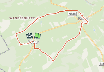

Lengte
8,6 km

Max. hoogte
492 m

Positief hoogteverschil
122 m
Km-Effort
10,2 km

Min. hoogte
432 m

Negatief hoogteverschil
123 m
Boucle
Ja
Datum van aanmaak :
2025-02-17 09:02:03.405
Laatste wijziging :
2025-02-17 09:03:18.23
2h19
Moeilijkheid : Medium

Gratisgps-wandelapplicatie
 SityTrail
IGN / Geografische instituten
SityTrail Plus
De wereld gaat voor u open
Over ons
Tocht Stappen van 8,6 km beschikbaar op Wallonië, Luxemburg, Houffalize. Deze tocht wordt voorgesteld door anjodena.
Plaatsbepaling
Land:
Belgium
Regio :
Wallonië
Departement/Provincie :
Luxemburg
Gemeente :
Houffalize
Locatie:
Unknown
Vertrek:(Dec)
Vertrek:(UTM)
703089 ; 5552339 (31U) N.
Opmerkingen