


(Houffalize) - Les Blancs Bois (promenade A) Fond noir, rectangle vertical blanc au milieu

anjodena
Gebruiker
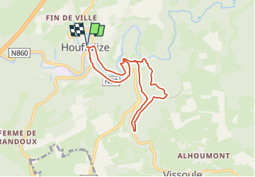

Lengte
6,7 km

Max. hoogte
425 m

Positief hoogteverschil
162 m
Km-Effort
8,8 km

Min. hoogte
328 m

Negatief hoogteverschil
162 m
Boucle
Ja
Datum van aanmaak :
2025-02-17 10:22:16.292
Laatste wijziging :
2025-02-17 10:25:15.278
2h00
Moeilijkheid : Medium

Gratisgps-wandelapplicatie
 SityTrail
IGN / Geografische instituten
SityTrail Plus
De wereld gaat voor u open
Over ons
Tocht Stappen van 6,7 km beschikbaar op Wallonië, Luxemburg, Houffalize. Deze tocht wordt voorgesteld door anjodena.
Plaatsbepaling
Land:
Belgium
Regio :
Wallonië
Departement/Provincie :
Luxemburg
Gemeente :
Houffalize
Locatie:
Unknown
Vertrek:(Dec)
Vertrek:(UTM)
699330 ; 5557095 (31U) N.
Opmerkingen