


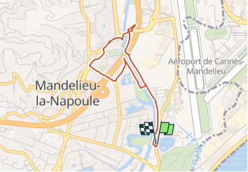
Sortie ravitaillement

rigol05
Gebruiker

Lengte
3,9 km

Max. hoogte
11 m

Positief hoogteverschil
27 m
Km-Effort
4,3 km

Min. hoogte
-1 m

Negatief hoogteverschil
26 m
Boucle
Ja
Datum van aanmaak :
2025-03-18 19:48:25.152
Laatste wijziging :
2025-03-28 17:16:10.279
58m
Moeilijkheid : Gemakkelijk

Gratisgps-wandelapplicatie
 SityTrail
IGN / Geografische instituten
SityTrail Plus
De wereld gaat voor u open
Over ons
Tocht Te voet van 3,9 km beschikbaar op Provence-Alpes-Côte d'Azur, Alpes-Maritimes, Mandelieu-la-Napoule. Deze tocht wordt voorgesteld door rigol05.
Beschrijving
Sortie du 18-03-2025 (matin)
Plaatsbepaling
Land:
France
Regio :
Provence-Alpes-Côte d'Azur
Departement/Provincie :
Alpes-Maritimes
Gemeente :
Mandelieu-la-Napoule
Locatie:
Unknown
Vertrek:(Dec)
Vertrek:(UTM)
334139 ; 4822753 (32T) N.
Opmerkingen