


HetM 2025

COGLAIS3
Gebruiker
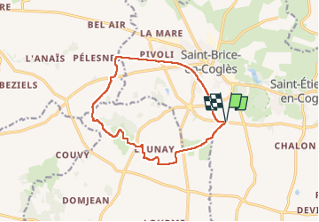

Lengte
12,2 km

Max. hoogte
120 m

Positief hoogteverschil
78 m
Km-Effort
13,2 km

Min. hoogte
94 m

Negatief hoogteverschil
78 m
Boucle
Ja
Datum van aanmaak :
2025-03-23 14:05:53.627
Laatste wijziging :
2025-03-23 16:39:40.329
2h29
Moeilijkheid : Heel gemakkelijk

Gratisgps-wandelapplicatie
 SityTrail
IGN / Geografische instituten
SityTrail Plus
De wereld gaat voor u open
Over ons
Tocht Noords wandelen van 12,2 km beschikbaar op Bretagne, Ille-et-Vilaine, Maen-Roch. Deze tocht wordt voorgesteld door COGLAIS3.
Plaatsbepaling
Land:
France
Regio :
Bretagne
Departement/Provincie :
Ille-et-Vilaine
Gemeente :
Maen-Roch
Locatie:
Saint-Brice-en-Coglès
Vertrek:(Dec)
Vertrek:(UTM)
621544 ; 5361542 (30U) N.
Opmerkingen