


Somme-Fort Mahon et Quend

nicolas54230
Gebruiker
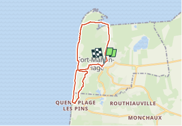

Lengte
11,5 km

Max. hoogte
17 m

Positief hoogteverschil
66 m
Km-Effort
12,3 km

Min. hoogte
0 m

Negatief hoogteverschil
63 m
Boucle
Ja
Datum van aanmaak :
2025-03-30 15:38:50.173
Laatste wijziging :
2025-03-30 15:39:29.653
2h48
Moeilijkheid : Moeilijk

Gratisgps-wandelapplicatie
 SityTrail
IGN / Geografische instituten
SityTrail Plus
De wereld gaat voor u open
Over ons
Tocht Stappen van 11,5 km beschikbaar op Hauts-de-France, Somme, Fort-Mahon-Plage. Deze tocht wordt voorgesteld door nicolas54230.
Plaatsbepaling
Land:
France
Regio :
Hauts-de-France
Departement/Provincie :
Somme
Gemeente :
Fort-Mahon-Plage
Locatie:
Unknown
Vertrek:(Dec)
Vertrek:(UTM)
398131 ; 5577610 (31U) N.
Opmerkingen