


Veluwe jour 3

dewaeph
Gebruiker
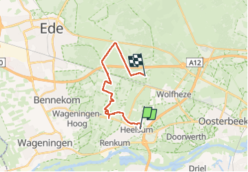

Lengte
16,2 km

Max. hoogte
44 m

Positief hoogteverschil
126 m
Km-Effort
17,8 km

Min. hoogte
14 m

Negatief hoogteverschil
123 m
Boucle
Neen
Datum van aanmaak :
2025-04-05 07:21:41.591
Laatste wijziging :
2025-04-05 12:17:45.355
4h55
Moeilijkheid : Moeilijk

Gratisgps-wandelapplicatie
 SityTrail
IGN / Geografische instituten
SityTrail Plus
De wereld gaat voor u open
Over ons
Tocht Stappen van 16,2 km beschikbaar op Gelderland, Onbekend, Renkum. Deze tocht wordt voorgesteld door dewaeph.
Plaatsbepaling
Land:
Netherlands
Regio :
Gelderland
Departement/Provincie :
Onbekend
Gemeente :
Renkum
Locatie:
Unknown
Vertrek:(Dec)
Vertrek:(UTM)
689464 ; 5762843 (31U) N.
Opmerkingen