


mauresque

ISAGIL
Gebruiker
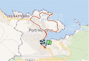

Lengte
4,6 km

Max. hoogte
48 m

Positief hoogteverschil
85 m
Km-Effort
5,7 km

Min. hoogte
-2 m

Negatief hoogteverschil
80 m
Boucle
Ja
Datum van aanmaak :
2025-04-09 11:58:25.227
Laatste wijziging :
2025-04-09 14:09:04.296
2h09
Moeilijkheid : Gemakkelijk

Gratisgps-wandelapplicatie
 SityTrail
IGN / Geografische instituten
SityTrail Plus
De wereld gaat voor u open
Over ons
Tocht Stappen van 4,6 km beschikbaar op Occitanië, Pyrénées-Orientales, Port-Vendres. Deze tocht wordt voorgesteld door ISAGIL.
Beschrijving
mauresque
Plaatsbepaling
Land:
France
Regio :
Occitanië
Departement/Provincie :
Pyrénées-Orientales
Gemeente :
Port-Vendres
Locatie:
Unknown
Vertrek:(Dec)
Vertrek:(UTM)
508810 ; 4707051 (31T) N.
Opmerkingen